I spent a couple of years between July 2015 and October 2017 walking the Shetland Coast line.
I was initially inspired by reading Peter Guys guide books. I had used them and Noel Fojuts "Viking and Prehistoric Shetland" book in the past before going out for family walks and found them a well of information and inspiration.
My friend and work colleague James Manson had walked the Shetland coast line, before me, taking photos every few hundred yards and I decided to do the same.
I had just started walking when I spoke to Walter Scott MBE a fellow Scalloway man.
https://www.shetlandbynumbers.com/
Walter told me the rules that he had used, namely keeping within 2-3 metres of the edge unless on particularly dangerous sections or weather conditions, then up to ten metres from the edge is permitted. That sounded similar to what I had been doing so I decided to stick to the same rules on all my future walks. I went back and re-did any walks that I may have been out-with this standard.
I still intend to revisit both Fair Isle and Foula.
As I was finishing the coast I was wondering about a new challenge.
I started walking the ridges of the Shetland Mainland as there are plans afoot to ruin them by erecting a massive wind farm.
I wanted to see them and the native wildlife in their natural glory before they are destroyed.
I then thought I could combine this with Mapping the Shetland Mainland Watershed. I would then walk it in a continuous journey as I couldn't find any record of it having been done before.
I successfully finished walking and mapping the watershed in early 2018 and again searched the web and found that Jim Bloomer had worked out a series of watersheds throughout the UK including Shetland.
(http://www.hill-bagging.co.uk/). On close inspection I found that he had mistakenly put Ronas Hill on their route and I wrote to tell him, he didn't reply but he changed their route.
I realised that he hadn't walked the watershed, when mapping it, but had done it just by reading a map and listing what he thought were all the key high points. This is a good start, I did this when I started planning my route, but found that the real work is the mapping in-between the high points as the subtle nuances between contours means not all the tops are part of the actual watershed, this can only be found by getting out and walking it. In some areas I had to visit and walk the area 3 or 4 times to get clarity. This was easiest in winter and after a lot of rain as you could see more easily where the water was flowing.
In the end I feel that I walked the Watershed and mapped it to within a few metres in most instances, with the occasional marsh area being potentially 25 -50 Metres out.
I noticed that the Hill-bagging site has another hill marked on that is incorrect (The Hill of Sandvoe in North Roe) and two tops marked where due to the geography below, aren't part of the watershed (Trig point above Quarff and Muckle Ward in North Roe) it is found slightly further along the ridge. I haven't bothered writing to them as I don't think they are realistically claiming that their route is the definitive route, but just a rough guide for their readers.
June 2019 Since writing this blog I have been informed that the hill bagging sites classification of a watershed is completing all the Tumps (hills with a drop of 30 Metres all around) along the watershed, but not actually walking the watershed. I find their site a bit miss-leading as the impression it gives me is that of completing the watershed which of course it doesn't.
Once I had finished walking and mapping the route in separate sections, I marked the route into my Viewranger App on my phone. This has probably cost a small loss in accuracy. I then re-walked the route over the course of 8 continuous days.
In practise I found because you are on a hike rather than a mapping expedition, your walking route will be less accurate, even with using my Viewranger App, than it was during the initial mapping exercise.
I am still certain that I was well within the 200 Metres accuracy that is the standard mentioned in the Hill bagging site. I feel sure that I was never as much as 100 Metres out, at worst, at any time.
Heading to the start point at the Sumburgh Light House a Life sized display Orca.

Tammy Norries (Puffins)


The old restored Fog Horn

At the start point, South of the Light House


By chance I met a walking magazine Journalist ( Danny Carden) up on holiday and he Kindly took a couple of photos of me shortly after the start.


Guillemots


Looking back at route along cliff edge.


Technician carrying out maintenance.

Route towards Airport


WW2 Shelters


The route I took goes over the top of the Dunes. If you used the beach or the road you would still be within route boundaries.


Looking back


Looking back


More WW2 ruins


Betty Mouats cottage, now a camping Bode (Think luxury Bothy)

Past Scatness archaeological site.

Cross the runway After speaking to Security in their gate hut.

One of the small sections of road.


Excellent local shop for picking up supplies

Back to the hills. Fields are narrow so it is still possible to follow Watershed within acceptable boundries if crops or livestock don't allow access when following out door access code.

War time ruin

Looking back


Fitfull head covered in low cloud


I came onto the road here as cattle and Hay fields would have had to be crossed. I am still within 50 Metres of Watershed. In Winter When I mapped the Watershed I was able to walk through the fields as they were empty.


A Shetland croft house museum well worth a detour, but not today

Shetland Ponies

On the left another excellent local shop for resupplies.


Betty Mouats Grave


I went on old road as the new road has altered the watershed slightly.
I tried to follow the geographical watershed but will try to acknowledge mans alterations.

This old lady has seen better days


A loop around Vatchley


Croft Ruin

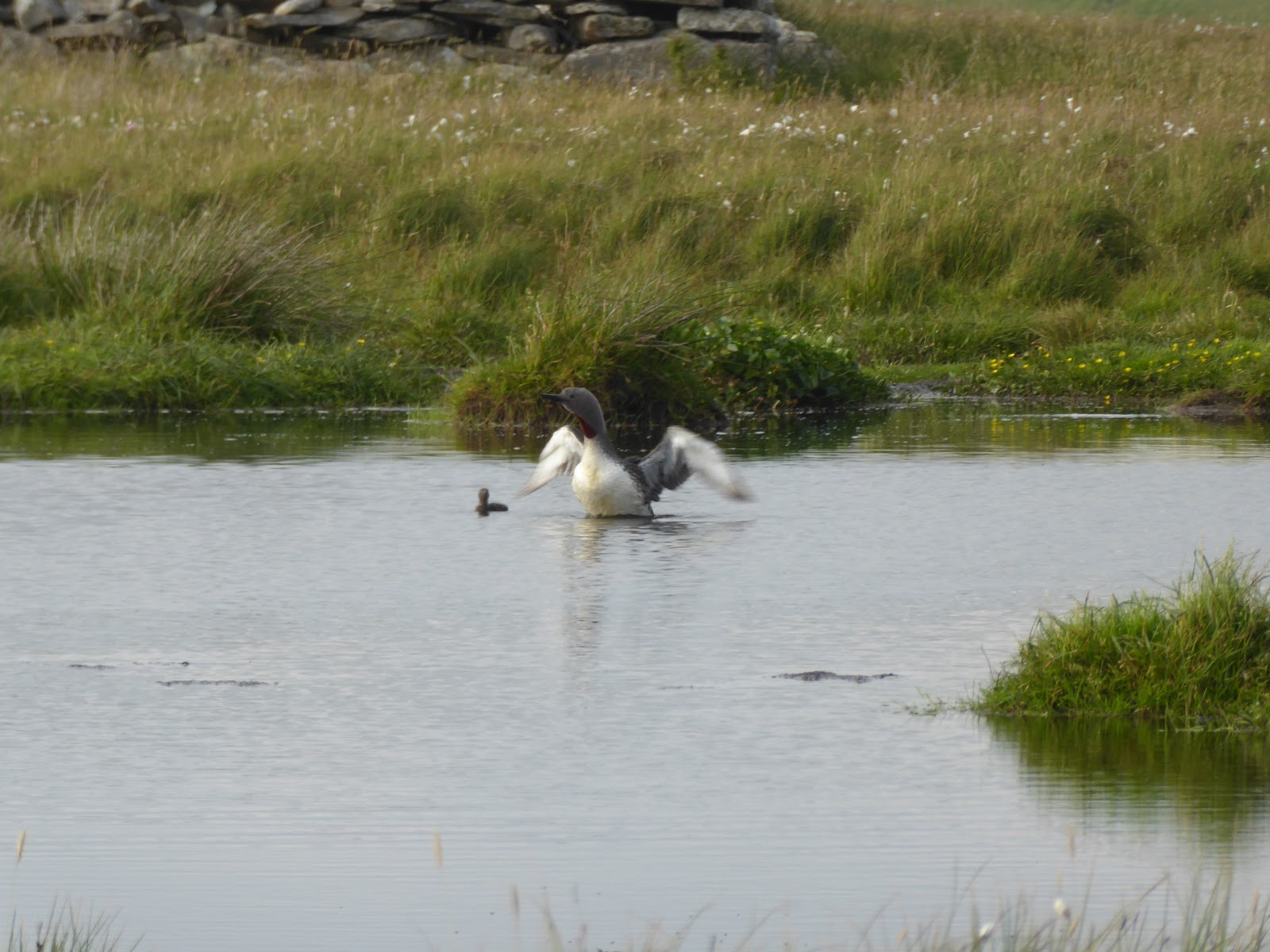
Red Throated diver and Chick. Very much a protected bird. photo shot from range to avoid disturbance.
I have found that they will be very much threatened/decimated when/if Shetlands proposed transformation into a windfarm takes place, due to the nesting sites locations I found along my route.


Up the Ward of Scousburgh.

Past old ruined croft

Geese Chick


old trig point 298 M


Ward of Scousburgh Cairn ?

Remains of Decommissioned Mossy hill Army Signals equipment.


End first days walk watching Ferry leaving Shetland to Aberdeen it appears to be flying due to strange lighting and weather condition.


In practise I found because you are on a hike rather than a mapping expedition, your walking route will be less accurate, even with using my Viewranger App, than it was during the initial mapping exercise.
I am still certain that I was well within the 200 Metres accuracy that is the standard mentioned in the Hill bagging site. I feel sure that I was never as much as 100 Metres out, at worst, at any time.
From Sumburgh Head Light House to Ward of Scousburgh
26/06/2018
26/06/2018
Heading to the start point at the Sumburgh Light House a Life sized display Orca.

Tammy Norries (Puffins)


The old restored Fog Horn

At the start point, South of the Light House


By chance I met a walking magazine Journalist ( Danny Carden) up on holiday and he Kindly took a couple of photos of me shortly after the start.


Guillemots

Looking back at route along cliff edge.


Technician carrying out maintenance.

Route towards Airport


WW2 Shelters


The route I took goes over the top of the Dunes. If you used the beach or the road you would still be within route boundaries.


Looking back


Looking back


More WW2 ruins


Betty Mouats cottage, now a camping Bode (Think luxury Bothy)


Cross the runway After speaking to Security in their gate hut.

One of the small sections of road.


Excellent local shop for picking up supplies

Back to the hills. Fields are narrow so it is still possible to follow Watershed within acceptable boundries if crops or livestock don't allow access when following out door access code.

War time ruin

Looking back


Fitfull head covered in low cloud

Erne's Ward 86M


I came onto the road here as cattle and Hay fields would have had to be crossed. I am still within 50 Metres of Watershed. In Winter When I mapped the Watershed I was able to walk through the fields as they were empty.


A Shetland croft house museum well worth a detour, but not today

Shetland Ponies

On the left another excellent local shop for resupplies.


Betty Mouats Grave


I went on old road as the new road has altered the watershed slightly.
I tried to follow the geographical watershed but will try to acknowledge mans alterations.

This old lady has seen better days


A loop around Vatchley


Croft Ruin

Red Throated diver and Chick. Very much a protected bird. photo shot from range to avoid disturbance.
I have found that they will be very much threatened/decimated when/if Shetlands proposed transformation into a windfarm takes place, due to the nesting sites locations I found along my route.


Up the Ward of Scousburgh.

Past old ruined croft

Geese Chick


old trig point 298 M


Ward of Scousburgh Cairn ?

Remains of Decommissioned Mossy hill Army Signals equipment.


End first days walk watching Ferry leaving Shetland to Aberdeen it appears to be flying due to strange lighting and weather condition.


Daily Mileage 10.4 Miles
Total Ascent 629 M
Total Descent 426 M
Hi Neil,
ReplyDeleteGreat to stumble across this. I was the 'walking magazine journalist' you bumped in to at Sumburgh. (I work in communications for Ramblers Scotland.) I'm very glad to hear that you made it and I've really enjoyed the photos.
We were staying at Papil and I kept looking up at the Clift Hills and wondering how you were getting on. I'm glad that you survived the Bonxies!
All the best,
Danny.
This is lovely. Thank you. I’m thinking of visiting Shetland to hike. I’m not sure yet whether I would be looking at the watershed ir coast but this looks lovely. Is your map available?
ReplyDeleteNeil, thank you very much for your photos and comments. It is really interesting. I have been looking at visiting Shetland to hike and I had wondered about the coastline or watershed. May I ask if your map is available?
ReplyDeleteLorna
Hi thank you Lorna. It was on view ranger but that site has been taken over by outdooractive. I could try to send you a copy if you were to visit. My oldest Son and I completed Yell and Unst watershed last year So we have maps for the Watershed of the 3 Significant islands, giving a total mileage of about 148 Miles. Some of the middle section is now sadly spoilt by windfarm roads that are being put in so access would be difficult for the next year or so.
DeleteUnless you specifically wanted to do the watershed, then I think you would maybe find walking sections of the coast more rewarding scenically, for sighting wildlife, and for historic sites. I have walked all the coast line and have nearly completed doing all the 1Km ordnance survey squares. So if you decide to come please write and I will point you towards anything you are specifically interested in.